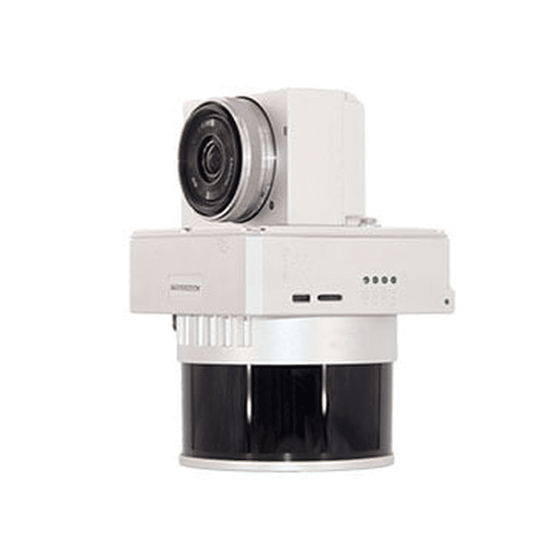
LiDAR GS-130X Solution for UAVs The high-efficiency “one-key” system for topographic and infrastructure surveysThe GS-130X integrates a 32beam LiDAR scannerwith dual echoes, a high-performance POS (GNSS INS), and-in option-a 26 MP camera into a single compact body.With its “one-key” workflow and included Shuttle and gAirHawk software,it is possible to conduct centimeter surveys up to 120 m away at a density of 1 280 000 points/s.Ideal for smart cities, precision agriculture, infrastructure monitoring, mining surveys, and forestry. 1280kpoint/sec dual-echopoint rate 120mt maxrange 1.0cm rangeprecision 26MP integratedcamera 360°fov circularview 200hz imusensor Main features:32-beam LiDAR scanner with dual echoes to capture multiple surfaces separatelyDensity of points: up to 1 280 000 points/sUseful range: up to 120 m (10 % reflectivity)Measurement accuracy: ± 1 cmHigh-frequency POS: update GNSS INS at 200 Hz, positioning accuracy ≤ 0.05 mAdjustment: Roll/Pitch 0.005° – Heading 0.017°Compact and lightweight: 1.26 kg; dimensions 11.5 × 11 × 12 cmRugged: operation from -20 °C to 55 °C; compatible with multi-rotor and VTOLBuilt-in camera (optional): 26 MP, FOV 83°, focal length 16 mm Main Advantages and Benefits“One-key” quick start: planning and acquisition in a few clicks, with automatic pre-processingCentimeter accuracy: reliability for critical applications such as urban mapping and infrastructure inspectionsHigh productivity: wide coverage per flight, superior point density and automated workflowApplication versatility: from mining survey to terrain modeling, from power grid control to smart city projectsComplete software ecosystem: Shuttle for POS trajectories, gAirHawk for classification and point-cloud post-processing RGB coloring of the point cloudAll 3D LiDAR systems can be equipped, via plug-&-play “EXT” interface, with external or integrated cameras.Photographic acquisition and centimeter georeferencing of images are handled automatically by the on-board GNSS, ensuring perfect synchronization between LiDAR and RGB data. By connecting one or more cameras to the LiDAR sensor, the corresponding color information can be applied to individual points, enriching the point cloud with high-resolution visual details. The coloring step is also performed fully automatically within the same post-processing software provided with the system. PPK technology for centimeter georeferencingThanks to Post-Processing Kinematic (PPK), no more ground targets are needed: point cloud and RGB images directly achieve centimeter accuracy during processing. The included Shuttle software automatically handles all correction and georeferencing steps, ensuring a fast and reliable workflow. Fully automatic GPS correctionImmediate extraction and export of RINEX logsAccuracy up to 2 cm RMS**Compatible with any GNSS base station (real-time VRS or CORS networks)** Values measured in PPK mode Terrain Mapping Inspection of Power Lines Mining Survey Implementation of Smart City Technical Specifications Voce Specifiche Modello GS-130X Scanner LiDAR 32 fasci, doppio eco Punti per secondo 1 280 000 pt/s Lunghezza d’onda 905 nm, Classe 1 (IEC 60825-1:2014) Portata massima 120 m @10 % riflettività Campo visivo 360° regolabile Accuratezza misura ± 1 cm Update rate POS 200 Hz Accuratezza posizionamento ≤ 0,05 m Accuratezza assetto Roll/Pitch 0,005° – Heading 0,017° GNSS GPS L1/L2/L5; GLONASS L1/L2; BDS B1/B2/B3; Galileo E1/E5a/E5b Fotocamera (opzionale) 26 MP; FOV 83°; focale 16 mm Storage 64 GB (espandibile a 128 GB via TF card) Peso 1,26 kg Dimensioni 11,5 × 11 × 12 cm Temperatura operativa –20 °C… 55 °C Piattaforma supportata Multi-rotor / VTOL Software incluso Shuttle (POS trajectory) • gAirHawk (point-cloud processing) • WayPoint Master Contact Us Now! Request a free consultation or a demo at our office!Fill out the form below and our experts will contact you. Or Call Us Now: 0541.1790411Contact Us Now! Request a free consultation or a demo at our office!Fill out the form below and our experts will contact you. Or Call Us Now: 0541.1790411Contact Us Now! Request a free consultation or a demo at our office!Fill out the form below and our experts will contact you. Or Call Us Now: 0541.1790411Field is required!Field is required!First Name*Field is required!Field is required!Last Name*Field is required!Field is required!Email*Field is required!Field is required!Phone*Field is required!Field is required!City*Field is required!Field is required!CountryField is required!Field is required!Company / Organization*Field is required!Field is required!VAT / Tax ID*Field is required!Field is required!Insert Your note here*Field is required!Field is required!All fields marked with * are mandatoryAll fields marked with * are mandatoryAll fields marked with * are mandatoryField is required!Field is required!I have read, understood and accepted the Privacy Policy and the Terms of Sale (required).Field is required!Field is required!Subscribe to our newsletter and stay informed about all the News and OffersField is required!Field is required![{"f":"{newsletter}","l":"contains","v":"newsletter","fa":"","va":""}][{"f":"{newsletter}","l":"contains","v":"newsletter","fa":"","va":""}]Send Your Request