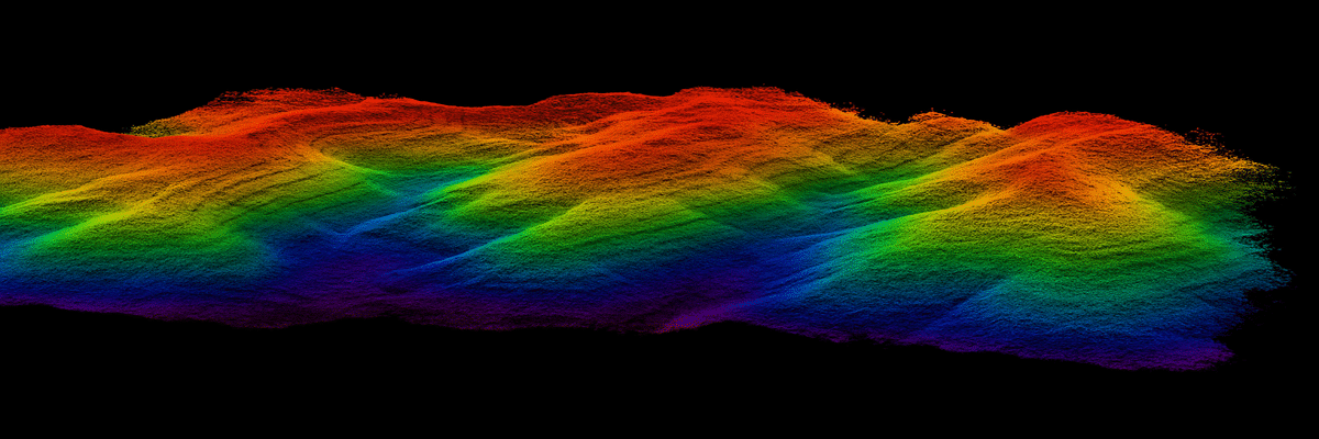
GS-260X LiDAR Solution for UAVsThe GS-260X is an ultra-compact LiDAR designed for drones, ground vehicles and VTOL platforms.Weighing only 1.1 kg and with a footprint of 14.4 × 10.9 × 12 cm, it offers a maximum range of 300 m and generates up to 1.92 million points per second. With support for triple return and photo synchronization in real time, it captures point clouds and RGB images simultaneously, even in dense vegetation.Ideal for terrain mapping, power-line inspections, forestry and smart-city surveys, it provides fast and comprehensive workflow. 1920 rkpoint/sec dual-echopoint rate 300mt maxrange 10cm rangeprecision 26MP integratedcamera 360°fov circularview 200hz imusensor Main features:High accuracy: up to 1.92 M pt/s with absolute accuracy of 10 cm at 150 mTriple return: acquisition of multiple echoes to penetrate vegetative coversLow weight (1.1 kg): maximum portability and easy integration on drones and vehiclesMulti-platform: compatible with UAVs, VTOLs and ground vehiclesRGB synchronization: integrated 26 MP camera (FOV 80°) for georeferenced photo textures Main Advantages and Benefits“One-key” efficiency: quick startup, data acquisition and automatic pre-processingReliability in all conditions: operation from -20 °C to 55 °C and robust voltage range (12-24 V)High productivity: coverage of up to 2.52 km² in a single flight at 150 m altitudeSoftware ecosystem: market-leading point-cloud classification and mission planning with WayPoint Master RGB coloring of the point cloudAll 3D LiDAR systems can be equipped, via plug-&-play “EXT” interface, with external or integrated cameras.Photographic acquisition and centimeter georeferencing of images are handled automatically by the on-board GNSS, ensuring perfect synchronization between LiDAR and RGB data. By connecting one or more cameras to the LiDAR sensor, the corresponding color information can be applied to individual points, enriching the point cloud with high-resolution visual details. The coloring step is also performed fully automatically within the same post-processing software provided with the system. PPK technology for centimeter georeferencingThanks to Post-Processing Kinematic (PPK), no more ground targets are needed: point cloud and RGB images directly achieve centimeter accuracy during processing. The included Shuttle software automatically handles all correction and georeferencing steps, ensuring a fast and reliable workflow. Fully automatic GPS correctionImmediate extraction and export of RINEX logsAccuracy up to 2 cm RMS**Compatible with any GNSS base station (real-time VRS or CORS networks)** Values measured in PPK mode Terrain Mapping Inspection of Power Lines Mining Survey Implementation of Smart City Technical Specifications Voce Specifiche Modello GS-260X Portata massima 300 m @10 % Punti per secondo 1 920 000 pt/s Accuratezza assoluta 10 cm @150 m Densità nuvola di punti 50 pt/m² @150 m @10 m/s Scanner LiDAR 32 linee, triplo echo Campo visivo (FOV) 360° (orizzontale) / 40,3° (verticale) Accuratezza intervallo ± 0,5 cm Unità POS (GNSS INS) gSpin 310, update rate 200 Hz Accuratezza posizionamento ≤ 0,020 m orizzontale / 0,030 m verticale Accuratezza assetto Pitch/Roll: 0,005° • Heading: 0,017° GNSS System GPS L1/L2/L5; GLONASS L1/L2; Galileo E1/E5a/E5b; BDS B1c/B1/B2/B2a/B2b/B3 Fotocamera integrata 26 MP; FOV 80°; focale 16 mm Storage 64 GB (espandibile a 128 GB via TF card) Peso 1,1 kg Dimensioni 14,4 × 10,9 × 12 cm Consumo elettrico 20 W Alimentazione 12–24 V Temperatura operativa –20 °C … 55 °C Piattaforma supportata Multi-rotor / VTOL / Vehicle Operation Efficiency (50/100/150 m) 228 pt/m² → 1 km²; 160 pt/m² → 1,68 km²; 80 pt/m² → 2,52 km² Software incluso Point-Cloud Automata • WayPoint Master Contact Us Now! Request a free consultation or a demo at our office!Fill out the form below and our experts will contact you. Or Call Us Now: 0541.1790411Contact Us Now! Request a free consultation or a demo at our office!Fill out the form below and our experts will contact you. Or Call Us Now: 0541.1790411Contact Us Now! Request a free consultation or a demo at our office!Fill out the form below and our experts will contact you. Or Call Us Now: 0541.1790411Field is required!Field is required!First Name*Field is required!Field is required!Last Name*Field is required!Field is required!Email*Field is required!Field is required!Phone*Field is required!Field is required!City*Field is required!Field is required!CountryField is required!Field is required!Company / Organization*Field is required!Field is required!VAT / Tax ID*Field is required!Field is required!Insert Your note here*Field is required!Field is required!All fields marked with * are mandatoryAll fields marked with * are mandatoryAll fields marked with * are mandatoryField is required!Field is required!I have read, understood and accepted the Privacy Policy and the Terms of Sale (required).Field is required!Field is required!Subscribe to our newsletter and stay informed about all the News and OffersField is required!Field is required![{"f":"{newsletter}","l":"contains","v":"newsletter","fa":"","va":""}][{"f":"{newsletter}","l":"contains","v":"newsletter","fa":"","va":""}]Send Your Request