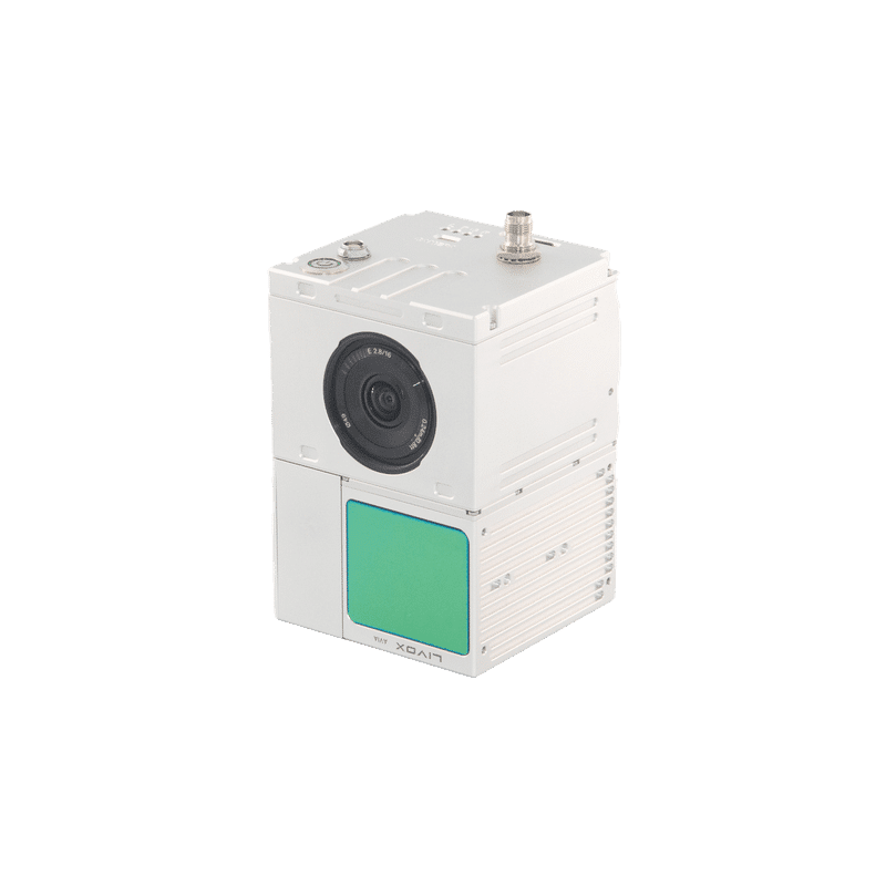
GS-100C The GS-100C is an entry-level short-range LiDAR solution,designed for integration on multiplatforms such as multirotors and VTOLs. With a weight of just 1 kg, it combines: A Livox Avia laser scanner with triple echo capability,A high-precision IMU (gSpin 210, 200 Hz),A 26 MP RGB camera with an 80° field of view.This combination provides high-density point clouds (up to 720 000 points/s), multi-constellation GNSS data (GPS L1/L2/L5, GLONASS, Galileo, BDS), and synchronized photographic footage. With its excellent price-performance ratio, the GS-100C is suitable for many mapping applications, particularly in corridor surveying, infrastructure monitoring, and environmental surveys. 720kpoint/sec dual-echopoint rate 450mt maxrange 2.0cm rangeprecision 26MP integratedcamera 80°fov circularview 200hz imusensor Main features:Low weight (1 kg): easily transported and installed on light aircraft.Triple echo: maximum spot capture even in dense vegetation.High dot density: up to 720 000 dots/s for extreme detail.Wide field of view: 70°×4.5° laser and 80° chamber for optimal coverage.Multi-constellation GNSS: increased robustness and reliability of positioning.Compatibility: power supply 12-24 V, operating temperature -20 °C to 55 °C. Main Advantages and BenefitsOperational efficiency: range up to 1.92 km² in a single flight at 150 m altitude.Centimeter accuracy: horizontal accuracy ≤ 2 cm and vertical accuracy up to ± 2 cm at 100 m distance.Reduced operating costs: highly cost-effective LiDAR system, ideal for small and medium-sized fleets.Software integration: includes leading point-cloud classification solutions and WayPoint Master flight planning software.Application versatility: ideal for construction, power line monitoring, forest mapping, mining surveys and smart cities. RGB coloring of the point cloudAll 3D LiDAR systems can be equipped, via plug-&-play “EXT” interface, with external or integrated cameras.Photographic acquisition and centimeter georeferencing of images are handled automatically by the on-board GNSS, ensuring perfect synchronization between LiDAR and RGB data. By connecting one or more cameras to the LiDAR sensor, the corresponding color information can be applied to individual points, enriching the point cloud with high-resolution visual details. The coloring step is also performed fully automatically within the same post-processing software provided with the system. PPK technology for centimeter georeferencingThanks to Post-Processing Kinematic (PPK), no more ground targets are needed: point cloud and RGB images directly achieve centimeter accuracy during processing. The included Shuttle software automatically handles all correction and georeferencing steps, ensuring a fast and reliable workflow. Fully automatic GPS correctionImmediate extraction and export of RINEX logsAccuracy up to 2 cm RMS**Compatible with any GNSS base station (real-time VRS or CORS networks)** Values measured in PPK mode Terrain Mapping Inspection of Power Lines Mining Survey Implementation of Smart City Technical Specifications Voce Specifiche Modello gSpin 210 Laser Scanner Livox Avia (equivalente a 64-beam, triplo eco) Punti per secondo 720.000 punti/s Risoluzione camera 26 MP Field of View Laser: 70°×4,5°; Camera: 80° Portata massima 450 m Accuratezza misura ± 2 cm Accuratezza GPS Orizzontale 0,020 m; Verticale 0,030 m Accuratezza assetto Roll/Pitch: 0,015°; Heading: 0,040° Densità alla quota 100 m 140 punti/m² (a 10 m/s) Quota di volo consigliata 50 m → ≤ 5 cm; 100 m → ≤ 7 cm; 150 m → ≤ 10 cm Copertura per volo singolo 0,88 km² (50 m); 1,28 km² (100 m); 1,92 km² (150 m) IMU Update Rate 200 Hz GNSS System GPS L1/L2/L5; GLONASS L1/L2; Galileo E1/E5a/E5b; BDS B1c/B1/B2/B2a/B2b/B3 Storage 64 GB (fino a 128 GB su TF card) Peso 1 kg Dimensioni 13,6 × 9,4 × 9,1 cm Consumo elettrico 20 W Alimentazione 12–24 V Temperatura operativa -20 °C… 55 °C Piattaforma supportata Multi-rotor / VTOL Software incluso Point cloud classification & post-processing; WayPoint Master Contact Us Now! Request a free consultation or a demo at our office!Fill out the form below and our experts will contact you. Or Call Us Now: 0541.1790411Contact Us Now! Request a free consultation or a demo at our office!Fill out the form below and our experts will contact you. Or Call Us Now: 0541.1790411Contact Us Now! Request a free consultation or a demo at our office!Fill out the form below and our experts will contact you. Or Call Us Now: 0541.1790411Field is required!Field is required!First Name*Field is required!Field is required!Last Name*Field is required!Field is required!Email*Field is required!Field is required!Phone*Field is required!Field is required!City*Field is required!Field is required!CountryField is required!Field is required!Company / Organization*Field is required!Field is required!VAT / Tax ID*Field is required!Field is required!Insert Your note here*Field is required!Field is required!All fields marked with * are mandatoryAll fields marked with * are mandatoryAll fields marked with * are mandatoryField is required!Field is required!I have read, understood and accepted the Privacy Policy and the Terms of Sale (required).Field is required!Field is required!Subscribe to our newsletter and stay informed about all the News and OffersField is required!Field is required![{"f":"{newsletter}","l":"contains","v":"newsletter","fa":"","va":""}][{"f":"{newsletter}","l":"contains","v":"newsletter","fa":"","va":""}]Send Your Request