$22.21
$31.09
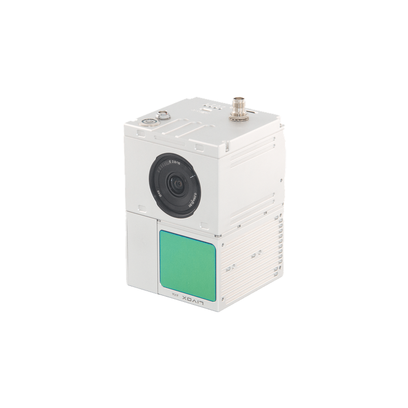
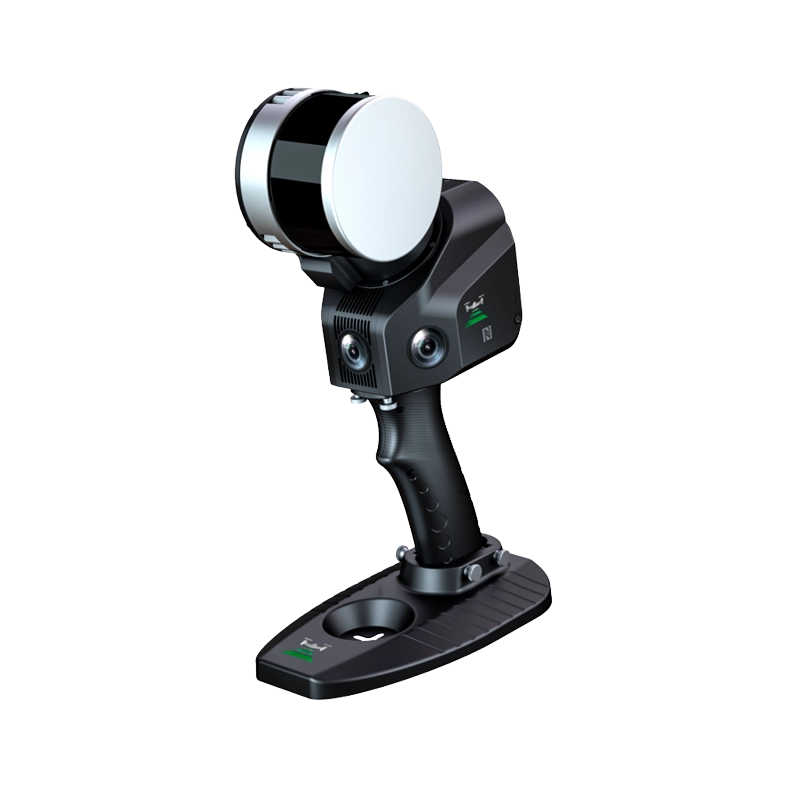
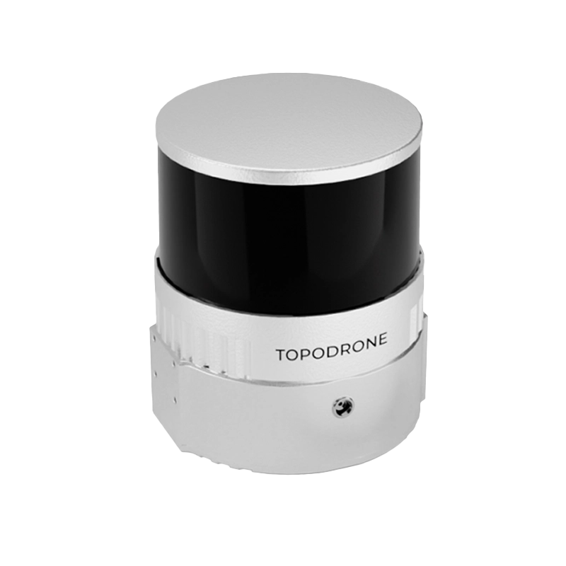
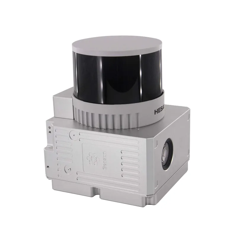
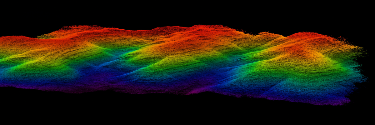
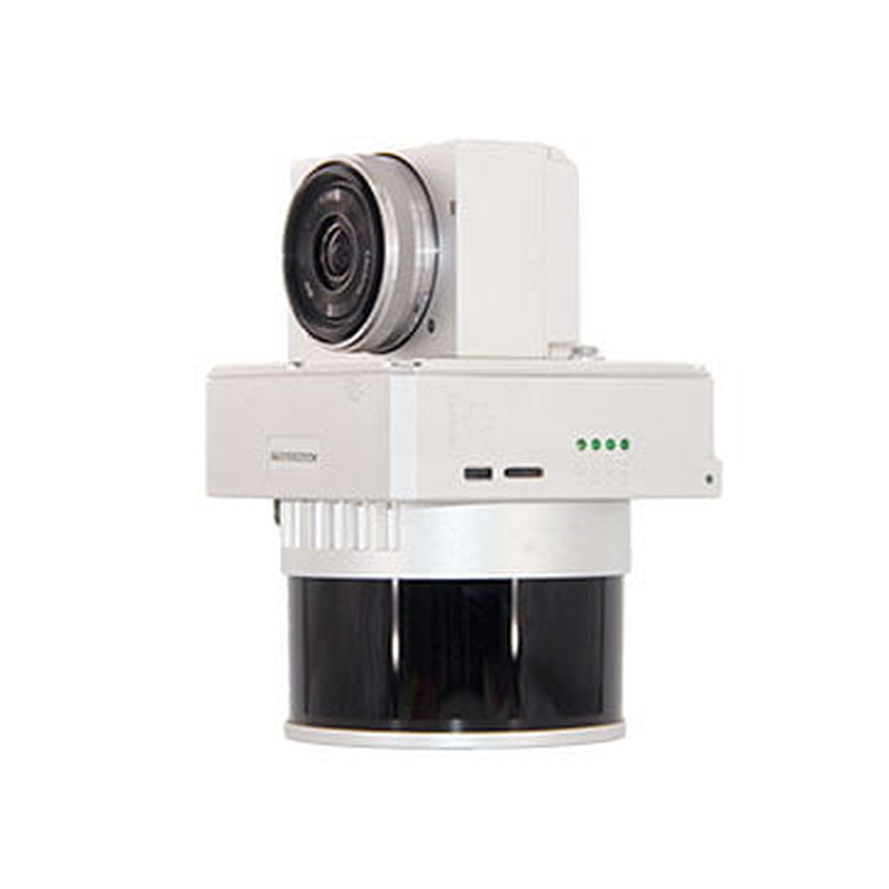
Laser Scanner Slam GS-100G Series The GS-100G series is an advanced laser scanning solution based on SLAM (Simultaneous Localization and Mapping) technology, designed for real-time high-precision 3D mapping. This portable scanner is ideal for mobile surveying and mapping applications, with the ability to collect accurate 3D data in complex environments. With its ruggedness and ease of use, the GS-100G is perfect for professionals who need reliable solutions for surveying buildings, infrastructure, and difficult-to-access environments. Laser Scanner Slam GS-100G Series The GS-100G series is an advanced laser scanning solution based on SLAM (Simultaneous Localization and Mapping) technology, designed for real-time high-precision 3D mapping. This handheld scanner is ideal for mobile surveying and mapping applications, with the ability to collect accurate 3D data in complex environments. With its ruggedness and ease of use, the GS-100G is perfect for professionals who need reliable solutions for surveying buildings, infrastructure, and difficult-to-access environments. 640kpoint/sec dual-echopoint rate 120mt maxrange 1.5cm rangeprecision 3 x 5 MP integratedcamera 360°fov circularview 200hz imusensor Main features:Advanced SLAM Technology: Enables the creation of accurate 3D maps in real time without the need for GPS, ideal for urban environments and spaces with limited access.High-precision detection: Equipped with the latest generation of LiDAR sensors, it provides exceptional resolution and millimeter accuracy in data collection.Portable and compact design: The lightweight and easy-to-handle design makes the GS-100G ideal for field operations, providing high mobility without compromising performance.Intuitive interface: Easy to use, with clear controls and a real-time data display, making information acquisition faster and less error-prone.GNSS/INS integration: The combination of GNSS and INS (Inertial Navigation System) improves mapping accuracy in harsh environments or inside buildings.High software compatibility: Supports various LiDAR data processing software for in-depth map analysis and 3D model creation. Main Advantages and BenefitsHigh precision: advanced SLAM with tolerances of ±1.5 cm (GS-100G/GS-120G) and ±1 cm (GS-130G) for detailed mapping.Compact design: Lightweight and portable, suitable for field operations, mountable on backpack or usable manually.Speed and efficiency: Fast data acquisition (up to 1.9 million points per second), reducing work time.Versatility: Ideal for urban mapping, surveying and 3D modeling, even in harsh environments.Autonomy: Up to 2 hours of continuous use with 11600 mAh battery.Advanced technology: integrated GNSS and INS for high accuracy, even in poor satellite visibility.Integrated software: Support for data processing, compatible with other mapping solutions.Durable: Operates in extreme environments from -20°C to 55°C. 3D mapping of environments exterior and interior Topographic surveys for construction and infrastructure Monitoring and building inspections GIS applications and urban mapping Technical Characteristics Caratteristiche GS-100G GS-120G GS-130G Accuratezza Assoluta ≤ 5 cm ≤ 5 cm ≤ 5 cm Durata della Batteria 2 ore 2 ore 2 ore Peso 2.15 kg 2.15 kg 1.7 kg Memoria di Archiviazione 128 GB 128 GB 128 GB Capacità della Batteria 11600 mAh 11600 mAh 11600 mAh Consumo Energetico 25 W 25 W 25 W Piattaforma di Trasporto Manuale, Zaino Manuale, Zaino Manuale, Zaino Temperatura di Funzionamento -20°C a 55°C -20°C a 55°C -20°C a 55°C Tensione di Funzionamento 12V - 18V 12V - 18V 12V - 18V POS (Sistema di Posizionamento) gSpin 210 gSpin 210 gSpin 210 Frequenza di Aggiornamento IMU 200 Hz 200 Hz 200 Hz Sistema GNSS GPS L1/L2/L5; GLONASS L1/L2; GAL E1/E5a/E5b; BDS B1c/B1/B2/B2b/B3 GPS L1/L2/L5; GLONASS L1/L2; GAL E1/E5a/E5b; BDS B1c/B1/B2/B2b/B3 GPS L1/L2/L5; GLONASS L1/L2; GAL E1/E5a/E5b; BDS B1c/B1/B2/B2b/B3 Accuratezza di Posizione 0.020 m orizzontale, 0.030 m verticale 0.020 m orizzontale, 0.030 m verticale 0.020 m orizzontale, 0.030 m verticale Accuratezza di Pitch 0.015° 0.015° 0.015° Accuratezza di Roll 0.015° 0.015° 0.015° Accuratezza di Heading 0.040° 0.040° 0.040° Gamma di Misurazione 120 m 120 m 300 m Accuratezza della Gamma ±1.5 cm ±1.5 cm ±1 cm Canali del Laser 16 canali 32 canali 32 canali Dati Acquisiti 640,000 punti/sec 1,280,000 punti/sec 1,920,000 punti/sec Campo Visivo (FOV) 270°/360° 270°/360° 270°/360° Risoluzione della Fotocamera 2×20 MP 2×20 MP 2×20 MP Metodo di Mappatura SLAM, RTK-SLAM, PPK-SLAM SLAM, RTK-SLAM, PPK-SLAM SLAM, RTK-SLAM, PPK-SLAM Software Software di elaborazione del punto nuvola sviluppato internamente Software di elaborazione del punto nuvola sviluppato internamente Software di elaborazione del punto nuvola sviluppato internamente Contact Us Now! Request a free consultation or a demo at our office!Fill out the form below and our experts will contact you. Or Call Us Now: 0541.1790411Contact Us Now! Request a free consultation or a demo at our office!Fill out the form below and our experts will contact you. Or Call Us Now: 0541.1790411Contact Us Now! Request a free consultation or a demo at our office!Fill out the form below and our experts will contact you. Or Call Us Now: 0541.1790411Field is required!Field is required!First Name*Field is required!Field is required!Last Name*Field is required!Field is required!Email*Field is required!Field is required!Phone*Field is required!Field is required!City*Field is required!Field is required!CountryField is required!Field is required!Company / Organization*Field is required!Field is required!VAT / Tax ID*Field is required!Field is required!Insert Your note here*Field is required!Field is required!All fields marked with * are mandatoryAll fields marked with * are mandatoryAll fields marked with * are mandatoryField is required!Field is required!I have read, understood and accepted the Privacy Policy and the Terms of Sale (required).Field is required!Field is required!Subscribe to our newsletter and stay informed about all the News and OffersField is required!Field is required![{"f":"{newsletter}","l":"contains","v":"newsletter","fa":"","va":""}][{"f":"{newsletter}","l":"contains","v":"newsletter","fa":"","va":""}]Send Your Request
3D Lidar